
Relocating to Boston’s MetroWest
Where in Wellesley
should you live?
Wellesley is 10.5 square miles and 23 distinct neighborhoods. Which one fits depends on three things: how you get to work, how much land you want, and whether you want to walk to a train or a coffee. Start with the map.
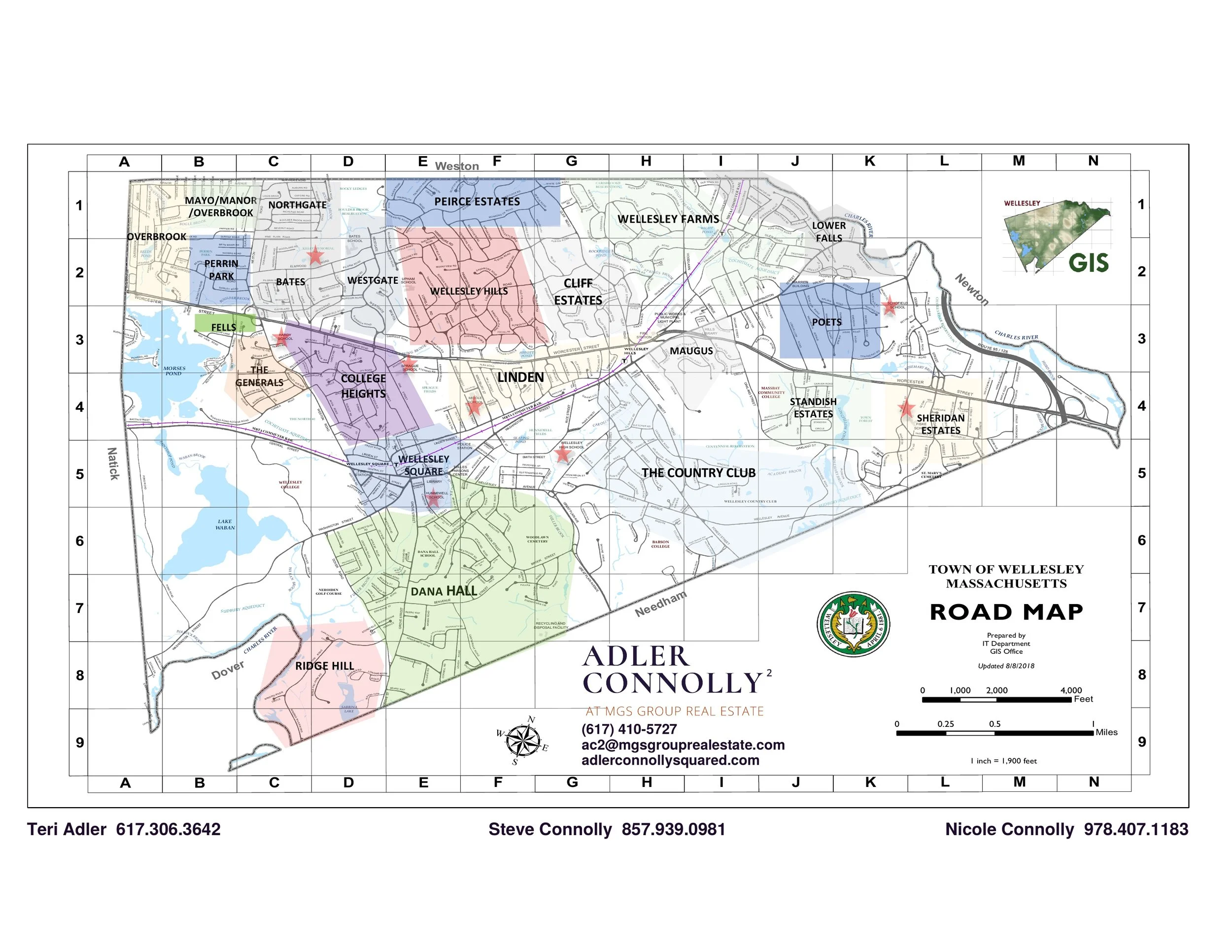
All 23 Wellesley neighborhoods at a glance
A quick read on every neighborhood on the map, with the nearest commuter rail stop or the way most residents get to one.
Want the short list? Read our ranking of the best neighborhoods in Wellesley, MA for 2026, check Wellesley median and average home prices, or start with the full guide to living in Wellesley.
Wellesley Farms
The northeast corner, tucked against the Newton line and the Charles. Older estate lots and winding streets, with the Farms platform inside a walk for much of it.
Cliff Estates
Large lots and long driveways on the north side of Route 9. One of the lowest-density pockets in town, and priced accordingly.
Wellesley Hills
Built around the Hills business block and its own train platform. A true walkable village center that is not the Square.
Peirce Estates
North edge against the Weston line. Quiet, wooded, and set apart from the through-traffic corridors.
Northgate
Northwest, near Morses Pond and the Weston border. Family streets with pond access in walking distance.
Mayo / Manor / Overbrook
The town’s far northwest shoulder, bordering Natick and Weston. Larger parcels, more trees, longer drives.
Overbrook
West side near the Natick line and Morses Pond. Quiet, established, and a genuine distance from Route 9.
Perrin Park
Built around its namesake park on the west side. Neighborhood-scaled streets with real green space at the center.
Bates
Anchored by Bates Elementary and a short hop from Morses Pond. Popular with families who want the school walk.
Westgate
Center-west, between Morses Pond and the Route 9 corridor. Convenient without being on top of the highway.
Fells
Compact west-side pocket near the Natick line. Smaller footprint, tighter street grid.
The Generals
West of the college, streets named for generals. Mid-century character with mature planting.
College Heights
Between Wellesley College and the Square. Among the best walk-to-everything positions in town — train, shops, and campus.
Wellesley Square
The downtown itself. Shops, restaurants, library, and the platform all on foot. Smaller lots, highest walkability.
Linden
The Linden Street corridor through the middle of town. Central to both village centers and the town’s services.
Maugus
East of Linden on the Hills side. Close-in, with the Hills platform and Route 9 both nearby.
Dana Hall
South of the Square around the Dana Hall campus. Leafy, private, and still a walk to downtown.
The Country Club
Wrapped around the Wellesley Country Club in the town’s southeast quadrant. Golf frontage and generous lots.
Lower Falls
The far northeast at the Charles and the Newton line. Closest point in town to I-95/128 and the fastest drive east.
Poets
Streets named for poets, on the Newton side of town. Convenient to the highway and to Newton’s amenities.
Standish Estates
East side near MassBay and the highway approaches. Practical for drivers heading into the city.
Sheridan Estates
The town’s eastern edge against Newton and the Charles. Larger parcels with the shortest run to 95.
Ridge Hill
The southern tip, bordering Dover and Needham. The most rural feel in Wellesley — conservation land and long lots.
The commute decides more than people expect
Wellesley has three stops on the MBTA Framingham/Worcester line, which is unusual for a town this size. Which one you live near shapes your morning far more than the town line does.
Wellesley Farms
The northeast corner, closest to the Newton line and the Charles. Wellesley Farms and the northern edge of Cliff Estates sit inside a walk.
Wellesley Hills
Route 9 and the Hills business block. Wellesley Hills, Maugus, and parts of Cliff Estates and Linden feed this platform.
Wellesley Square
The one that comes with shops, restaurants, and the library at the end of the walk. Wellesley Square, College Heights, Dana Hall, and lower Linden.
Driving instead? The east-side neighborhoods — Lower Falls, Poets, Standish Estates, Sheridan Estates — sit nearest I-95/128 and the Mass Pike connection.
Go deeper before you tour
2025 Wellesley Year in Review
Neighborhood-level pricing, absorption, and how last year actually closed.
Live dataInventory dashboard
What’s actually available right now, and how long it’s sitting.
New buildsNew construction tracker
Every new build we’re watching, mapped, with status.
The long readThe Wellesley Guide
Schools, taxes, town services, and the things nobody tells you until month three.
Questions we get from people moving in
Which Wellesley neighborhood is best for commuting into Boston?
If you want the train, anything inside a walk of Wellesley Farms, Wellesley Hills, or Wellesley Square station. If you drive, the east side of town — Lower Falls, Poets, Standish Estates, Sheridan Estates — puts you closest to I-95/128. The difference between a 7-minute walk to a platform and a 7-minute drive to one is the single most common regret we hear.
Are Wellesley’s neighborhoods actually different, or is it marketing?
They’re different. Lot sizes, street pattern, era of construction, and walkability vary sharply between, say, Cliff Estates and Wellesley Square. The names on this map are the ones the town itself uses, and they track real differences in how the streets were laid out.
We’re moving from Boston or Newton. What surprises people?
How much the specific street matters. Two houses a half mile apart can mean a different elementary school, a different walk to the train, and a materially different price per foot. That’s the whole reason this map exists.
Is there new construction in Wellesley?
Consistently, yes — mostly teardown-and-rebuild rather than subdivision. We track it live on the new construction tracker.
How far out should we start looking?
Earlier than feels reasonable. Buyers who tour neighborhoods before they’re ready to bid make faster, better decisions when a house does come up — especially relocating families working against a start date.
Want the neighborhood read for your situation?
Tell us where you’re commuting, what you need in a house, and when you have to be in. We’ll tell you which three neighborhoods to spend your Saturdays in — and which to skip.
Adler Connolly² at MGS Group Real Estate · (617) 410-5727 · adlerconnollysquared.com